

Joined April 2024
- Tweets 1,439
- Following 124
- Followers 58
- Likes 16,142
101 Photos and videos


Alex Cerrano retweeted

4h
Michael I love ya my man…
But this wasn’t unexpected

I think this is one of the closer examples in the modern era of a storm being “unexpected”. There was literally a several hour window where this went from ‘out to sea’ to blizzard.
I don’t think this level of “unexpected” however will ever match the mighty Blizzard ‘78. Thankfully, our technology today simply won’t allow for such an extreme surprise.

2
1
24
5,728
Alex Cerrano retweeted

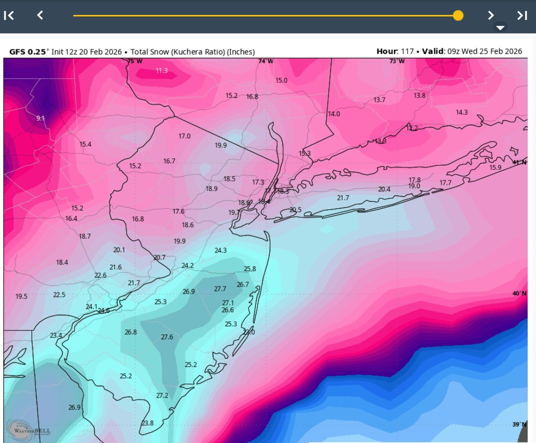
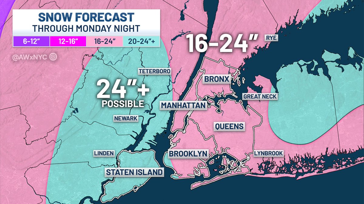
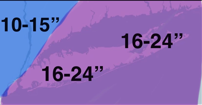
Here's my FINAL call for #NYC ❄️
The #Blizzard of 2026 will likely bring the city's biggest snowfall in at least 5 years. I factored in the two potential "heavy snow bands" with the blue color. It can still shift, as it's impossible to predict their exact location. Good night!
19
78
731
73,145

Alex Cerrano retweeted

Brother


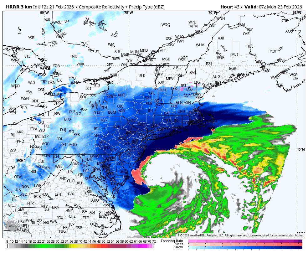
Hard to describe how freakin insane this 00z HRRR run is for the northeast
8
28
295
26,039
Alex Cerrano retweeted

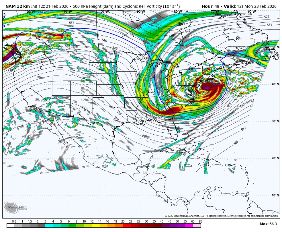
Pretty sure we can call it a Miller-A / HECS. (Historic East Coast Snowstorm)

8
21
201
14,337
Alex Cerrano retweeted

11h
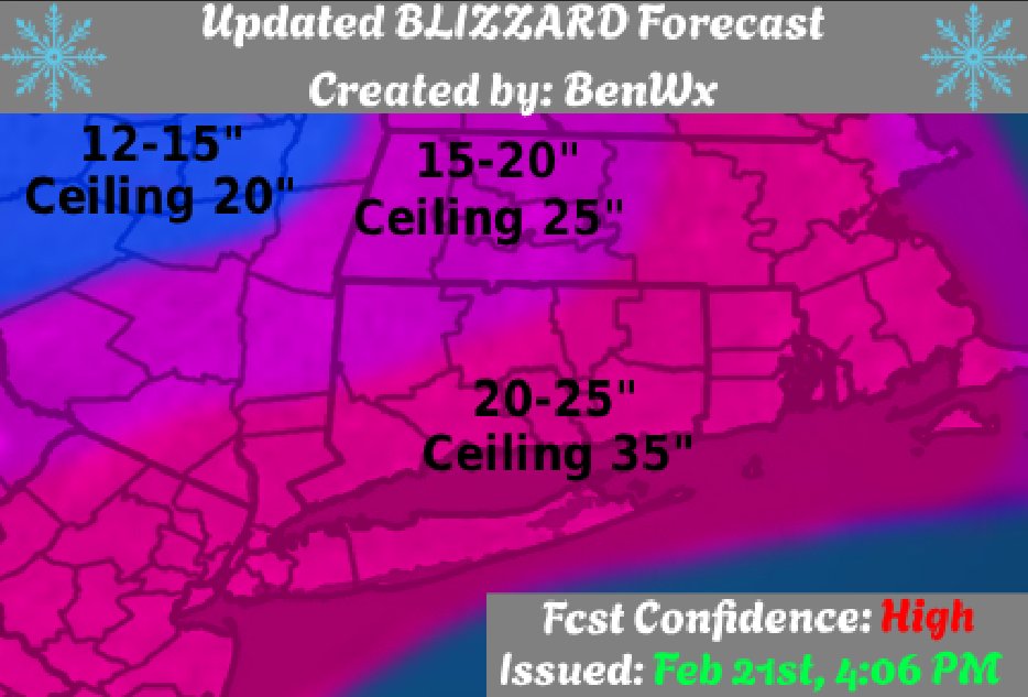
--Updated Blizzard Forecast--
The main change with this update was to change forecast confidence to "High" and expand the highest totals into NE Massachusetts. Ceiling 35", floor 12". Snowfall rates will exceed 2-4" per hour.
12
20
227
21,905
Alex Cerrano retweeted

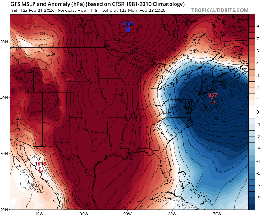
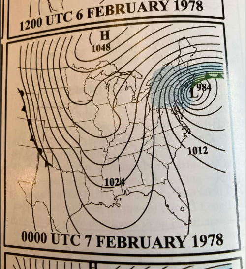
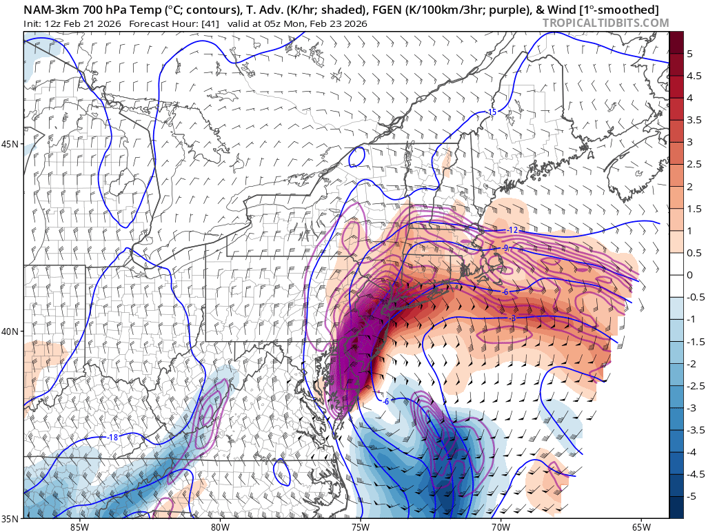
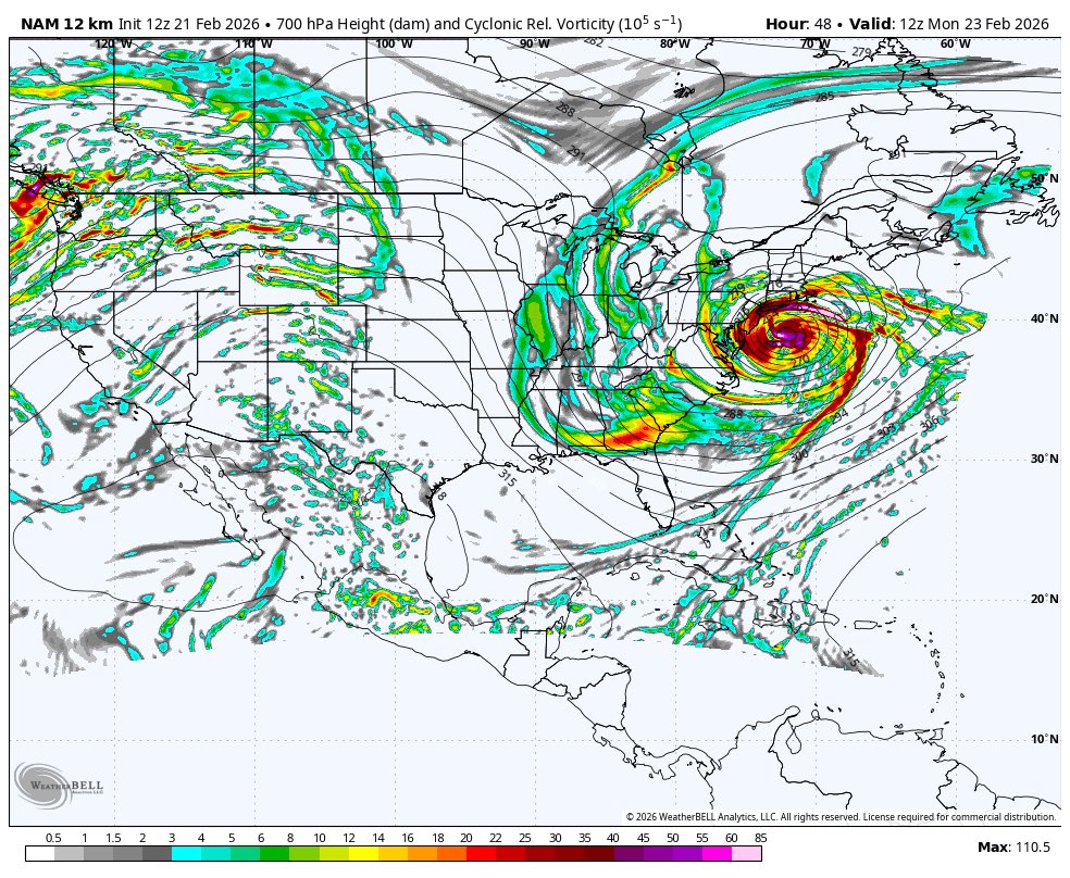
Two things I continue to marvel at as I watch the data come in this afternoon:
1) The astonishing gradient between the 1049mb High north of Lake Superior while the coastal low is bombing down to 967mb on the GFS. This absurd 82mb difference should help drive wind gusts up to hurricane force along the immediate coast.
2) How similar this surface map is in both placement and strength of the high pressure to the February 1978 setup.
10
25
137
35,483
Alex Cerrano retweeted

Brother what in the corncob Michael nobleskin Adam furry cornelius is this
38
30
545
33,933
Alex Cerrano retweeted

me after looking at every single new model forecast so far today
20
109
1,088
49,120
Alex Cerrano retweeted
17h
I honestly wasn’t even aware so many were without a clue that this was possible. Just shocking tbh…
If what ur saying about euro is hugging is true that’s maybe worse…
I just can’t stand such bright minds and decades of knowledge to go to waste on model p type hugging and snow map hugging.
It’s why I’m always at least curious what ur thoughts are because I know a lot of ur weight goes into current OBS.
Something I’ve tried to keep forcing myself to get better over the past several years
1
1
7
890
Alex Cerrano retweeted
The commentary floating around is lazy. Just say you bank your forecasting on the Euro and move it along for that is obviously where the change of heart began once that guidance woke up to reality. I ignored it and frequently do. It's not as if the components weren't trackable.
1
1
32
1,631
Alex Cerrano retweeted

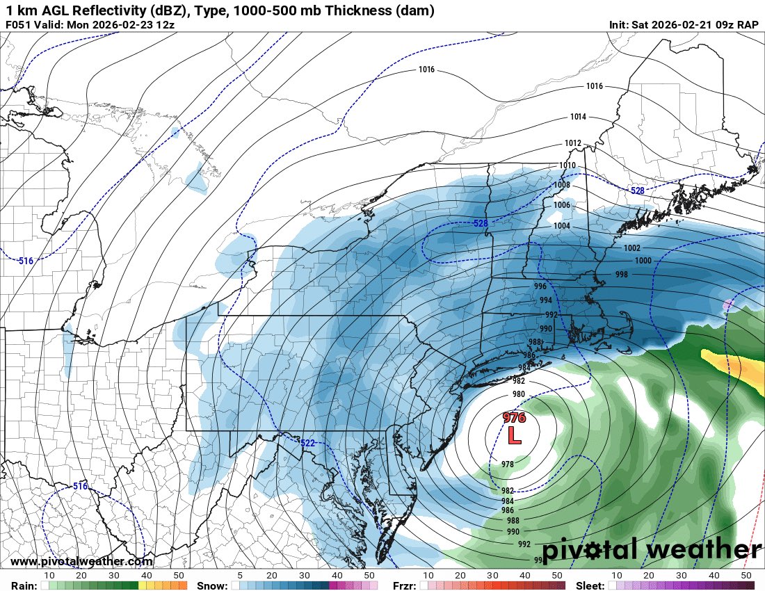
🚨🚨BLIZZARD WARNING 🚨🚨
HEAVY SNOW,Snowfall rates at 2-3” per hour at times during height of storm. Strong winds gusting to 50 MPH will create Blizzard conditions for NYC & LI. Visibility down to 1/4 Mile at times with whiteout conditions.
3
7
22
2,398
Alex Cerrano retweeted

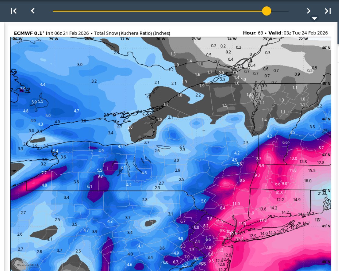
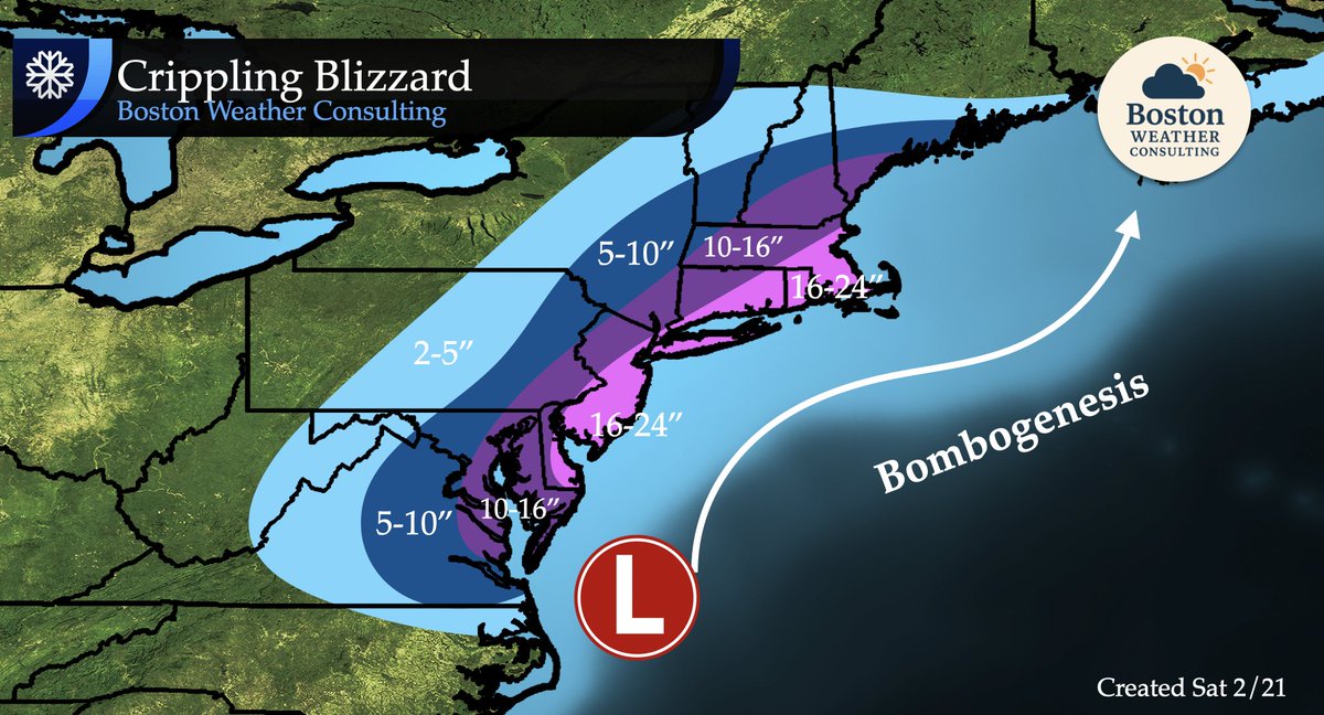
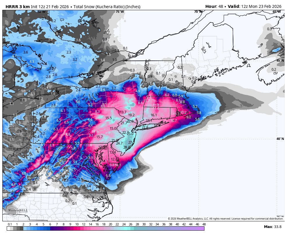
For those outside of SNE, here is the region-wide snowfall map. A crippling blizzard from DC to Boston.
2
11
135
17,856


Alex Cerrano retweeted

17h
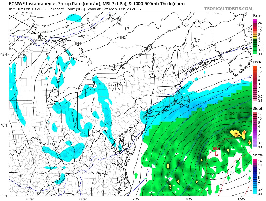
The heavy snow band will pivot through the NYC metro, but if the NAM/HRRR/GFS camp verifies, it’ll continue moving to the west until coming to a stall over eastern PA where the heaviest totals would happen. The eastern ECM/RGEM camp would favor the pivot axis over the NYC metro.

Is NYC & western L.I in this Heaviest Banding ?
6
4
76
25,923
Alex Cerrano retweeted
18h
Will post a second update to my snow map later this afternoon — if current trends hold, I’m inclined to add a 24-36” contour in NJ and/or eastern PA.
Extremely impressive forcing for a slow-moving snow band with snow rates over 2-4”/hour.
8
26
213
23,129
Alex Cerrano retweeted
18h
U literally couldn’t draw up something better in a text book.
Thats the mother-load…
4
4
94
5,399
Alex Cerrano retweeted

18h
I can tell you that upstream here in Arkansas, we had some convective cells overnight that weren't necessarily modeled and some of that was sleet/thundersleet, associated with that shortwave moving over the southern plains. If that helps. :D
3
1
10
634
Alex Cerrano retweeted

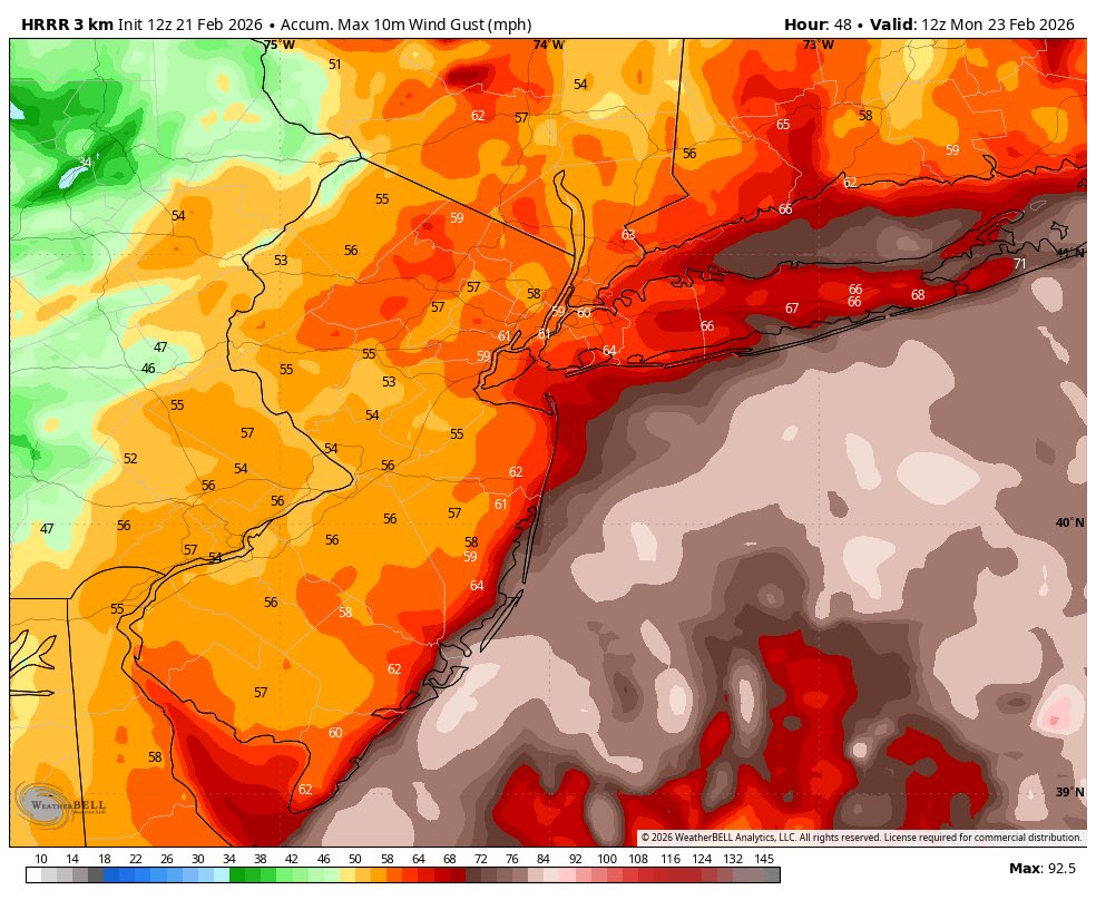
18h
HRRR NUKES THE NORTHEAST!!!! Still snowing too 😳

7
9
134
15,855